
この地図の30ヶ所はすべて正確な位置に配置されています。13つのエリアに分類されています(Day 2 - Tanabe to Takahara, Day 3 - Takahara to Chikatsuyu, Day 4 - Chikatsuyu to Honguほか)。 それぞれに、どんな場所で、なぜ訪れる価値があるかの短い説明が付いています。 閲覧は無料です。Ikuzoアカウントがあれば、地図全体をコピーして自分の旅程に作り変えられます。
Day 2 - Tanabe to Takahara
Kii-Tanabe Station
Day 2 entry to the Kumano region. Special Express Kuroshio from Shin-Osaka, ~2h. Bus from here to Takijiri.
Kumano Tourism Bureau (Tanabe)
English-speaking info center next to Kii-Tanabe Station. Maps, weather updates, lodging help. Worth a stop before catching the bus to Takijiri.
Takijiri-oji
Day 2 trailhead. Symbolic entrance to the sacred Kumano mountains. The Nakahechi pilgrimage starts here.
Kumano Kodo Kan Pilgrimage Center
Last chance to grab info, paper maps and stamp the dual pilgrim certificate before climbing toward Takahara.
Takahara (Kiri-no-Sato)
Day 2 overnight. Takahara, the Village in the Mist. ~7 km, +550 m from Takijiri. Sunset over the ridges is the reward.
Day 3 - Takahara to Chikatsuyu
Chikatsuyu-oji
Day 3 overnight. ~13 km, +830 m from Takahara. Quiet riverside village, several minshuku, easy day to settle into trail rhythm.
Day 4 - Chikatsuyu to Hongu
Hosshinmon-oji
Day 4 milestone. Gate of Spiritual Awakening, the last major oji before descending to Hongu. ~7 km from here to Hongu Taisha.
Kumano Hongu Taisha
Day 4 finish, ~22 km, +960 m total. Spiritual heart of the Kumano. Get a stamp at the office.
Oyunohara Otorii
Day 4 detour from Hongu Taisha. The world's largest torii, marking the original site of Kumano Hongu Taisha before the 1889 flood. Walk 5 min from the main shrine.
Day 5 - Yunomine Rest Day
Yunomine Onsen
Day 5 rest day. 1800-year-old hot spring village, the oldest onsen in Japan. Sleep here, recover, eat hot-spring eggs cooked in the public Yu-zutsu.
Tsubo-yu
UNESCO-listed micro onsen in a hut over the river. Reserve a 30-min slot at the Yunomine office. Color of the water shifts daily.
Day 6 - Hongu to Koguchi
Koguchi
Day 6 overnight after the Hongu to Koguchi stage (~20 km, +890 m). Tiny river hamlet, basic guesthouses. Carry water and snacks for tomorrow's brutal climb.
Day 7 - Koguchi to Nachi (hardest)
Ogumotori-goe Trailhead
Day 7 morning. Hardest Nakahechi stage starts here. Koguchi to Nachi via Ogumotori-goe and Kogumotori-goe, ~14 km, +1260 m. Eat well, leave early.
Kumano Nachi Taisha
Day 7 finish. The third Kumano grand shrine. Vermillion against the green mountains, with Nachi Falls thundering below. The full Nakahechi is done here.
Nachi Waterfall
Tallest waterfall in Japan (133 m), revered as a deity. Walk down from Nachi Taisha. The classic shot is the falls framed by the three-story pagoda of Seiganto-ji.
Approach to Seiganto-ji & Nachi Taisha
Stone steps approach from Daimon-zaka up through cedar trees. Final stretch of the Nakahechi if you are arriving from the Ogumotori-goe.
Day 8 - Coast Rest (Katsuura & Shingu)
Kii-Katsuura Station
Day 7 evening / Day 8 base. Bus down from Nachi (~30 min). Recommended over going back to Osaka. Tuna fishing town with onsen hotels for the rest day.
Kumano Hayatama Taisha
Day 8 morning. Third leg of the Kumano Sanzan trinity, in Shingu, near the river mouth. Easy day trip from Kii-Katsuura by train (~20 min).
Day 9 - Hongu to Totsukawa (Kohechi start)
Totsukawa Onsen
Day 9 overnight, ~20 km from Hongu on the Kohechi. Mountain hot spring village. Most guesthouses serve dinner and breakfast, ask for a packed lunch.
Day 10 - Totsukawa to Miura
Miura (Totsukawa)
Day 10 overnight area near Miura-guchi (~18 km from Totsukawa). Very small, very remote, book via Kumano Travel well in advance.
Day 11 - Miura to Omata
Omata Trailhead
Day 11 finish, ~17 km from Miura. Bus stop, public toilets, and the start of the final climb to Koyasan. Last lodging cluster before crossing into Koya.
Day 12 - Omata to Koyasan
Mount Koya (Koyasan)
Day 12 finish, ~14 km from Omata. The Kohechi ends here. Stay at a shukubo (temple lodging), eat shojin ryori, attend morning prayers.
Kongobuji Temple
Head temple of Shingon Buddhism. The rock garden (Banryutei) is the largest in Japan. Worth a slow visit on the rest day.
Day 13 - Koyasan Rest
Okunoin
Day 13. 200,000 graves under thousand-year-old cedars, ending at Kobo Daishi's mausoleum. Walk it at dusk or before dawn for the night-lantern atmosphere.
Recommendations
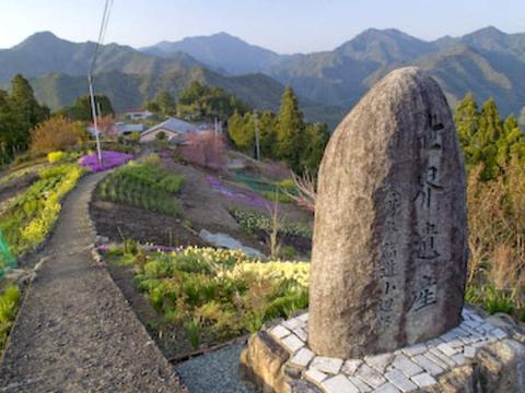
Hatenashi Toge Pass
小辺路
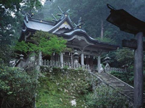
Tamaki Shrine
玉置神社 #torii
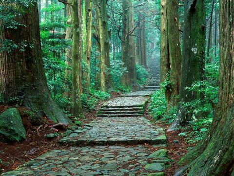
Daimonzaka
大門坂
Katsuura Fish Market (Nigiwai)
Day 8 morning option. Wakayama's biggest tuna port. Auction starts ~7am, the market hall has fresh tuna bowls and grilled fish. 5 min walk from Kii-Katsuura Station.
Konpon Daito Pagoda (Garan)
Day 13 must-visit on Koyasan. The 49 m vermillion pagoda at the heart of the Garan complex. Inside, the central pillar represents the cosmic Buddha Dainichi.
Daimon (Great Gate of Koyasan)
Day 13. Massive 25 m vermillion gate at the western edge of Koyasan, the historic main entrance. Walk here at sunset for views over the Kii mountains she just hiked across.